Welcome to the RAS Solution › Forums › HEC-RAS Help › Error creating a new terrain from a tif file
- This topic has 13 replies, 4,481 voices, and was last updated 9 years, 6 months ago by evuj31.
-
AuthorPosts
-
September 1, 2016 at 12:39 pm #6190evuj31Participant
hello to everyone ,I am a relatively new user of HEC-RAS 5.0.0 and I hope you can help me with the following problem.
I want to create a new terrain importing a tif file in RAS Mapper.
During step 2 of 4: Rounding and/or Generating Statistics…, the following error message occurs:
„Error creating Terrain: file does not contain a specified no data value tag.
cleaning files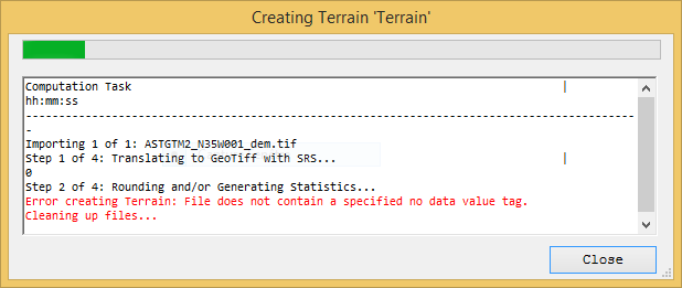 September 1, 2016 at 12:41 pm #10057evuj31Participant
to add another thing is that i can open this file normally with arcmap
September 1, 2016 at 7:53 pm #10058AnonymousGuestIn arc export your Tiff with a no data value of -999 (or your favorite na value). Should work.
If you use Program R you can use this script too
setwd(“my_path”)
r<-raster("DEM.tif") writeRaster(r, filename="DEM_NA.tif", format="GTiff", NAflag=-999, overwrite=TRUE)September 2, 2016 at 6:53 pm #10059evuj31Participantthanks i will try this
September 2, 2016 at 7:31 pm #10060evuj31Participantthanks to everyone i found the solution :it’s to use fill in arcmap found in spatial analyst and then export the filled file
September 3, 2016 at 1:25 am #10061AnonymousGuestIt’s worth noting this ‘filled file’ likely contains a terrain model that was filled in order to remove sinks. If so, this is a rough hydro-correction to generate a terrain model that allows water to flow downhill to an outlet. And the terrain raster at structure crossings ought to be scrutinized, particularly at culvert crossings.
November 29, 2016 at 10:36 am #10062AnonymousGuestSir, where i can find Program R windows?
November 29, 2016 at 5:00 pm #10063AnonymousGuestInformation on R can be found here:
https://www.r-project.org/I believe this link will get you to R Studio:
https://www.rstudio.com/products/rstudio/download3/November 30, 2016 at 10:07 am #10064AnonymousGuestSir,i think this link are blocked from our country.sir can you help me any other way how can i solve these problem manually. Actually sir,i will go for flood modeling by using HECRAS and this is my final year project.so please sir help me.
February 20, 2018 at 3:49 am #10066AnonymousGuestHello, Im using Qgis to generate de raster (geotiff). But I get the same error message (Error creating Terrain: File does not contain a specified no data value tag), when I try to create the terrain. Any ideas?? thanks!
March 11, 2018 at 4:03 pm #10067AnonymousGuestIf using QGIS then in the Translate (Convert format) dialog box you need to select the ‘no data’ option and assign a value, eg -999, before clicking OK to process conversion.
June 28, 2018 at 11:11 am #10069AnonymousGuestMadad maang raha hai ki bheekh maang raha hai???
Aise to kabhi madad nahin milegi..
THoda khud ka research kar aur specific sawaal pooch.January 3, 2019 at 1:42 pm #10068AnonymousGuestThank you Shane for your comment.
When I tried importing my buildings raster (polygons raised by 0.1m than my average DTM elevations) in HECRAS giving it as a top priority and my DTM as second; though the error has vanished and even I’m able to import it, I still have those 0 (zero) values everywhere other than the buildings which I had expected.
So my question is, is it good to stamp my buildings raster on DTM to generate a new DTM in any GIS tool and then importing it back to HECRAS, or am I missing some process while generating terrain?
Regards.
February 28, 2019 at 4:09 am #10065AnonymousGuestI DONT HAVE ARCMAP INSTALLED. IS THERE ANY WAY OUT?
-
AuthorPosts
- You must be logged in to reply to this topic.