Forum Replies Created
-
AuthorPosts
-
RasL DazLParticipant
Our group has decided the NOAA atlas 14 gridded PMP product is the best choice for our modeling effort.
http://hdsc.nws.noaa.gov/hdsc/pfds/pfds_gis.html
Thank you for the input.
RasL DazLParticipantThanks for the response Cameron.
RasL DazLParticipantThanks for your help.
RasL DazLParticipantHey Toby,
I tested the project on another machine and it worked as you described. I tried the reinstall on my “fast” computer and it still wouldn’t display. I’m beginning to think that this is specific to my computer. Is your machine 64 or 32 bit? What OS are you running?
Thanks so much for looking into my issue,
ChrisRasL DazLParticipantHi Toby,
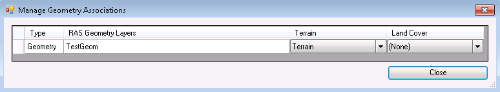
Thank you for your suggestions. I created the terrain in RAS Mapper from a tif that I exported from the LiDAR in ArcGIS. When I imported the tif and created the terrain I skipped assign projection because the tif already had a projection (NAD 83 UTM Zone 11). I did run into the no data issue and had to assign the no data value in order to import the terrain. The geometry is associated with the terrain:
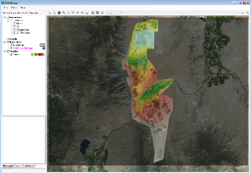
After terrain generation and export terrain to image everything displays in the correct location in RAS Mapper as verified by ArcGIS Web Imagery:
I will be performing a dam breach study and I believe the model will require combined 1D/2D modeling. The project is starting up soon so I’m trying to get myself up to speed fast. Its impossible to digitize 2D mesh into the the geometry at the correct location when you can’t see the terrain or land surface.
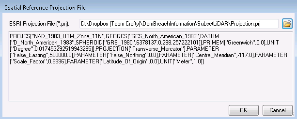
The project I posted earlier was referencing the projection file in a different directory on my local machine.
I have updated the project on Dropbox to include the projection file
(Projection.prj in NAD 83 UTM 11) and reposted the files:https://www.dropbox.com/s/i8w8x5uovm4oe2f/SubsetLiDAR.zip?dl=0
If you redownload and see the problem I having, you should be able to view the terrain in RAS Mapper, but not in the geometry window. I am totally stumped and just need to get to model building.
My previous registration for the blog didn’t go through correctly so I registered with a new name.
If you or others can find a few minutes and see if the terrain or image of terrain can be displayed in the geometry and potentially determine why it won’t display it would be very helpful.
Thanks,
RasL DazL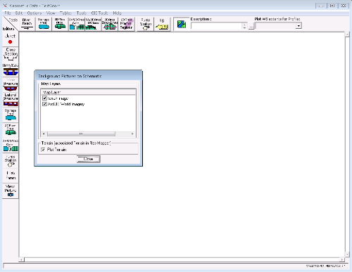
-
AuthorPosts