Forum Replies Created
-
AuthorPosts
-
Igloo_79Participant
Hi – yes, it seems that XS with Lids would be preferable for long culverts and/or where there is are changes in culvert profile. I tried modelling a 42m culvert using lids but got a crazy spike in WS elevation: http://hec-ras-help.1091112.n5.nabble.com/XS-with-Lid-very-high-water-surface-profile-td4426.html
Has anyone had similar issues?
Igloo_79ParticipantI am unclear about where XS with Lids should be used (as opposed to Bridges or Culverts). For instance, in this situation, couldn’t they be used for the entire structure, instead of modelling 2 culverts with XS inwith lids inbetween? What would be the pros/cons of the 2 approaches?
August 8, 2017 at 12:15 pm in reply to: Floodplain lower than channel – levee or ineffective flow? #10800Igloo_79ParticipantMany thanks for your reply.
2. Re: Ineffective flow areas – I don’t they are appropriate for this example.
3. I would like to model the amount of storage in the LOB, however, I don’t see how this can be done with standard channel XS since (as far as I understand) it’s not possible to model the LOB area gradually filling up with water after the channel overtops. Thus, my intention is to model out of bank flows via storage areas and lateral weirs.
Igloo_79ParticipantI faced the same problem after redrawing my centreline to more closely match the meandering channel planform. Tried deleting overlapping XS and restraightening the centreline, but no joy.
So I imported XS gradually reach by reach, eventually identifying a single XS causing Mapper to crash – the centreline was close to the L bank stn, so I moved the centreline away slightly – and problem solved!
May 24, 2017 at 12:24 pm in reply to: Problem with misaligned spatial projection (.prj) – British National Grid #10462Igloo_79ParticipantOk, so it seems that the WMS maps are projected to different coordinate systems e.g. Google Maps Global Mercator (Ras Mapper>Map Layers>Image Info).
I’ve gone back to my original .prj (British National Grid, 27700) to avoid potential issues with misaligned 2D mapping (e.g. my terrain layer is offset from my 1D geometry due to different projection systems), so have opted for using terrain and/or OS maps as my backdrop.
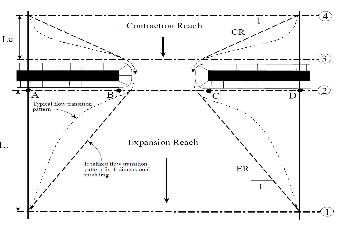
Igloo_79ParticipantThanks for your reply. Perhaps I should’ve phrased my query differently:
I understand that sections 1 & 4 (figure below) are required US and DS of the bridge – however, if there is no expansion or contraction length (i.e. there is no lateral obstruction to flow), then the placement of these sections is much more subjective.
I’d appreciate any feedback on how to locate these sections. For instance, can they be a significant distance away (e.g. 100m) if there are not significant changes in channel profile?
May 4, 2017 at 9:50 pm in reply to: Problem with misaligned spatial projection (.prj) – British National Grid #10460Igloo_79ParticipantMine were very similar. Have you experienced offset issues when loading terrain (e.g. DTM with the standard 27700 UCS), or when performing 2D floodplain modelling?
I am concerned that whilst the 1D network may appear to line up neatly with the WMS imagery, the offset could affect 2D flood mapping.
Igloo_79ParticipantI had a similar problem with British National Gird projection (see post below). Did you find a solution?
-
AuthorPosts
