Forum Replies Created
-
AuthorPosts
-
Chris G.Keymaster
Great!
Chris G.KeymasterYes you can do that. The “sharing” of flow will be tricky, and complicated, but I believe you should be able to handle that with lateral structures.
Chris G.KeymasterUpstream cross sections, yes. If you have a dendritic system, there will be multiple upstream cross sections (one for each branch). Make sure each one has a flow input.
Chris G.KeymasterIf you’re not sure, typically mixed flow will be the best. It properly combines both sub and supercritical profiles that are run and uses the momentum equation through hydraulic jumps. If you are running either super or subcritical only, there will be some errors around flow regime transition areas, or (obviously) anywhere there is not a valid solution for the selected regime.
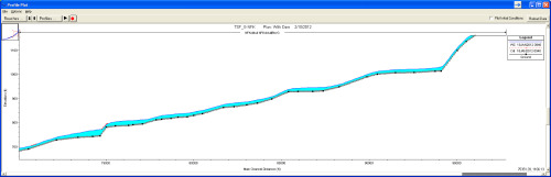
Chris G.KeymasterWhere are you looking for output? There are special output plots for sediment transport capacity. Please have a look through both the Users Manual and Hydraulic Reference Manual. They describe the process fairly well.
Chris G.KeymasterHard to say, but RAS needs flow in that cross section. Make sure you have flow inputs at all the upstream ends of your model for the full time series.
Chris G.KeymasterHow about setting the culvert up as a completely separate, but parallel reach? Then simulate the culvert with cross sections with “lids”. Lids will be better, since the empirical culvert routines included in RAS are meant for realtively short culverts (i.e. under highway bridges), not long tunnels. Suggest reading up on “Lids” and Priessman Slot in the manuals.
Chris G.KeymasterThe image doesn’t show up on my computer. Did you use the “Insert Image” above the message window? That will allow you to insert an image like this:
 Chris G.Keymaster
Yes, that would explain it. You can find out if your project is georeferenced, by checking the cross section cut lines table in the GIS Tools menu item of the Geometry window. If you have numbers in each cross section’s table, then they are georeferenced. What these numbers look like, might give you an idea of what coordinate system and projection was used, but you’d have to be a pretty crafty GIS type. Ideally, the original modeler would have left the projection information in the Description Box on the main RAS window, but that, unfortunately, doesn’t happen very often. You may be stuck trying different projections by trial and error. But you will save yourself a lot of time doing this if you get a good GIS analyst to help you.
Chris G.KeymasterHi Lee-
Can you post a screen shot of what you are talking about? What does your bridge opening look like? Is if very small relative to the channel size upstream and downstream? Also, you said it’s a concrete channel. Is it flowing supercritical?
Chris G.KeymasterYou can put the levees bounding your main channel. They don’t have to be on the cross section edges. Just be careful and understand that when the levee markers overtop, water will instataneously fill the interior side to the same level as the main channel. Otherwise, multiple parallel reaches is the way to go.
Chris G.KeymasterThe sdf file is an ascii text file. It can be read in any text editor. You should be able to manipulate the data in these files (either via programming, excel, or other) to get them into formats that can be read into GIS or any other software application that can read text files.
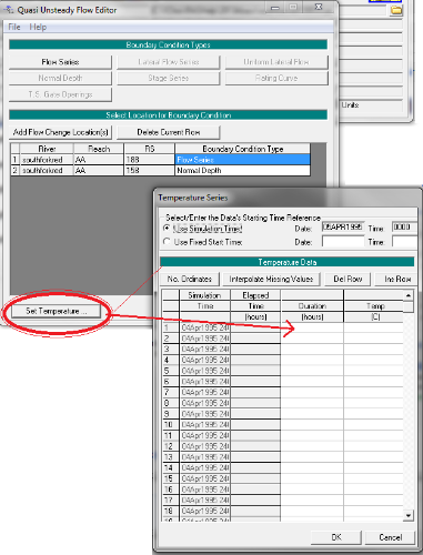
Chris G.KeymasterAs I mentioned in the first reply, you don’t have enough temperature data. Actually, you did not have it filled in. Please fill in this table so that it covers the simulation time, and then your program will run.
 Chris G.Keymaster
Reach lengths can be editted manually within HEC-RAS, both in the cross section editor and in the Reach Length table in the geometry schematic “Tables” menu item.
To automate the process of determining reach lengths, you have to use flow lines in HEC-GeoRAS.
Chris G.KeymasterIt’s possible. Also, remember that RAS dates use American convention and should either be input as 04/22/2013, or 22 Apr 2013. Time should be input in 24 hour convention – i.e. If the time you want to use is 2:41 pm, you would type 1441.
You may want to also make sure that you have English (American) for the internation settings in Windows.
Not sure if this will help, but I have nothing else I can think of.
-
AuthorPosts