Forum Replies Created
-
AuthorPosts
-
Chad BallardParticipant
Have you reviewed the Applications Guide and Users Manual (including the separate 2D users manual)?
This would be the first place I would start. If you have any specific questions as you are working through things post them here. The more specific the better your chances of getting a valuable response.
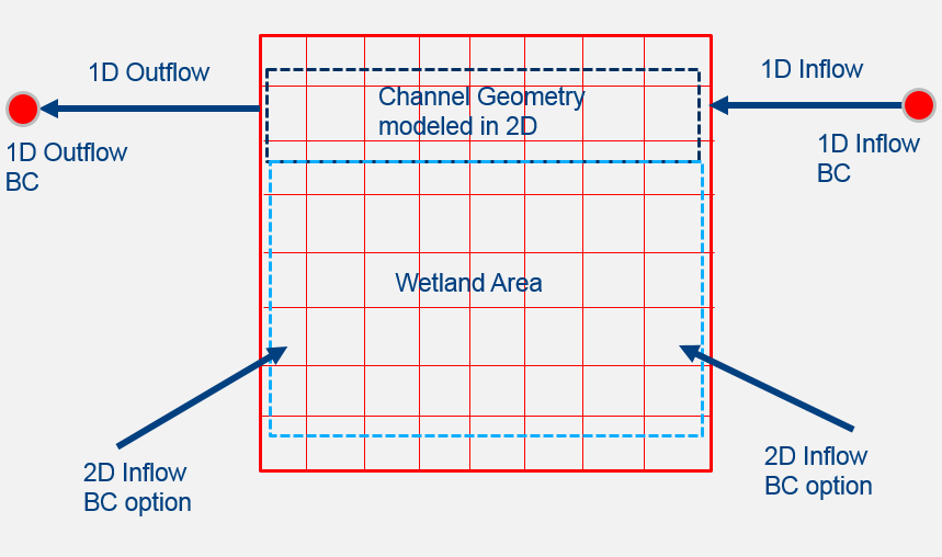
Chad BallardParticipantThis is kind of what is going on in my head.
 February 28, 2018 at 11:24 pm in reply to: culvert upstream and down stream opening is not same #11225Chad BallardParticipant
Have you thought about a rating curve instead? The approach that I would probably use would be to develop a rating curve outside of RAS then apply it to an inline structure to represent the culvert. Would be a tricky thing as the culvert changes from inlet to outlet control while I have not modeled a culvert like yours, I have used this approach to model complex structures that do not exactly fit the standard inputs.
Chad BallardParticipantHow about modeling the wetland as a 2D domain with 1D elements as inflow and outflow of the 2D domain?
Chad BallardParticipantThe boundary conditions force the model at the locations specified. The model will compute the water surface elevations and velocities in the channel for the given boundary conditions. The boundary conditions are the “knowns” of the model they can supported by a hydrology study or even better measured data.
Chad BallardParticipantWell when the flow runs in parallel with the 1D/2D connection then you can use a lateral structure. When the flow run perpendicular then you can connect the 1D cross section to the 2D flow area directly. Both options are outlined in the 2D Modeling User Manual.
Chad BallardParticipantIf you do not have a shp file that you can download for your area you can use QGIS to digitize a shapefile from an aerial image.
Chad BallardParticipantHave you tried forcing a WSE at the upstream? Do you need to have the SA/2D connection?
Chad BallardParticipant1D or 2D model?
Chad BallardParticipantNot within RAS that I know of. There is no option for a ‘No Fill’ in the contouring. You would have to export to a program like ArcGIS that has that contouring option.
Chad BallardParticipantThere are too many things to really get a specific answer for a very broad question. What I have found useful with modeling is to start off simple then add complexity bit by bit. Then I can pinpoint what is causing the problems with my model. For example a final 1D/2D model with lateral structures I would create a 1D model of the area and then run at various flows and look at the results. Once I am content then I might add connections to the 2D areas defined and run that at a few different flow values to see how the model is responding. Then further add the lateral structures, etc. By stepping through the modeling process this way you can locate the problems at each step. I see a lot of modelers throw everything together then hit go then they have a hard time finding out where there exact problem is.
Chad BallardParticipantNot sure why it is not working tried create the map on my current project and it worked. You do need to highlight and “Compute/Update Stored Maps” but I was able to export as a shp or KMZ file.
While I tried the process with your files I ran into the same problem that you are experiencing. Not sure why my files are working and yours are not but a workaround might be to export the Depth or WSE data into AcrGIS and use the “Raster Domain” tool.
May 26, 2017 at 7:42 pm in reply to: How do I import observed cross-section data into HEC-RAS or HEC-geoRas without drawing it? #10606Chad BallardParticipantYou cannot with just the “Elevation-Station” format. You are not passing in enough information into HEC-RAS to georeference. You would have to use the “X,Y,Z Format” option to georeference. In what format do you have the data?
May 25, 2017 at 3:41 am in reply to: How do I import observed cross-section data into HEC-RAS or HEC-geoRas without drawing it? #10604Chad BallardParticipantYou can import the data into HEC-RAS if you have a .csv file (Geometry Editor -> File Menu -> Import Geometry Data -> CSV (Comma Seperated Value) Format). There is a Station-Elevation Format supported (which your data looks to be in) so you need a .csv file with the following columns: “River”, “Reach”, “RS (River Station)”, “Station”, “Elevation”.
Chad BallardParticipantI have been using ArcGIS and creating a new raster similar to AJ but it takes some work to get it to reflect what is to be modeled. ARIS looks promising and more control cell by cell.
-
AuthorPosts