Forum Replies Created
-
AuthorPosts
-
cameronParticipant
Doesn’t do anything for the 2D results. The Mapping Output Interval controls the 2D outputs for Mapper.
cameronParticipantThis would all depend on the spillway geometry.
cameronParticipantAre you using the full momentum solver? What is your time step? Your model does not look stable to me.
cameronParticipantprobably a time step issue. Run the model with the full momentum solver and use dynamic time steps that are controlled by the courant number.
cameronParticipantWhat did you end up doing?
cameronParticipantChapter 20 of the user’s manual discusses how to get velocity and wse from Mapper which can then be used to get depth.
The other option would be HEC-GeoRAS
https://www.hec.usace.army.mil/software/hec-georas/downloads.aspx
cameronParticipantVersion 4.1 does have a Mapper, it is just a little more basic. You could just export the data for GeoHEC-RAS as well and create some layers in GIS.
cameronParticipantcameronParticipantDo you have any cross-sections that cross two stream centerlines (tributary cross-sections overlapping main river)?
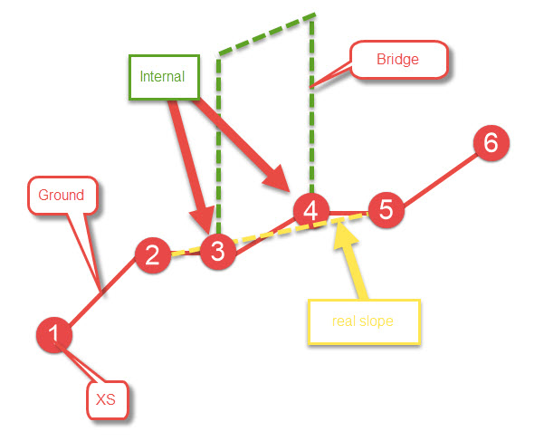
cameronParticipantWhen you make a bridge/culvert, the program creates two internal cross-sections which are exact copies of the bounding cross-sections including inverts. This means you have a flat (zero slope) area through the structure and does not depict reality where there is a slope through the bridge/culvert. So what you can do is adjust the internal cross-sections to follow the slope between the upstream and downstream cross-sections and not have the flat (zero slope) section.
I have seen in multiple cases when trying to do a no rise and having similar issues that just by lowering the upstream internal cross-section and raising the downstream internal cross-section to have a none flat slope the issue go away.
cameronParticipantDo you have any cross-sections where the stream center line is not in side the two bank stations?
cameronParticipantThe values on the right are for the internal cross-sections and not the structure.
cameronParticipantHave you tried modifying the internal cross-sections so they have a slope to them?
cameronParticipantWhat is your coordinate system in for the model?
April 27, 2020 at 4:43 pm in reply to: HEC-RAS 1D/2D _ Different Water Surface Elevation between 1D and 2D #12792cameronParticipantMake sure that the 1D/2D iteration option is turned on as that will force the wse to try and match. You may also want to adjust the weir coefficient to get a better match or just use the 2D equation for the weir which may be the best option, but watch out for the lateral structure bug with bridges.
(https://www.hec.usace.army.mil/software/hec-ras/known_issues.aspx)
-
AuthorPosts
