Welcome to the RAS Solution Forums HEC-RAS Help Where to draw 2D flow areas relative to 1D cross sections?

Viewing 6 posts - 1 through 6 (of 6 total)
  • Author
    Posts
  • #6636
    Igloo_79
    Participant

    I am building a linked 1D-2D unsteady flow model. When drawing the 2D flow areas (to be connected to the 1D reach with a lateral structure), I am uncertain where to place them in relation to the 1D cross sections. For instance, on the bank stations or at the end of the 1D cross sections (or in between)?

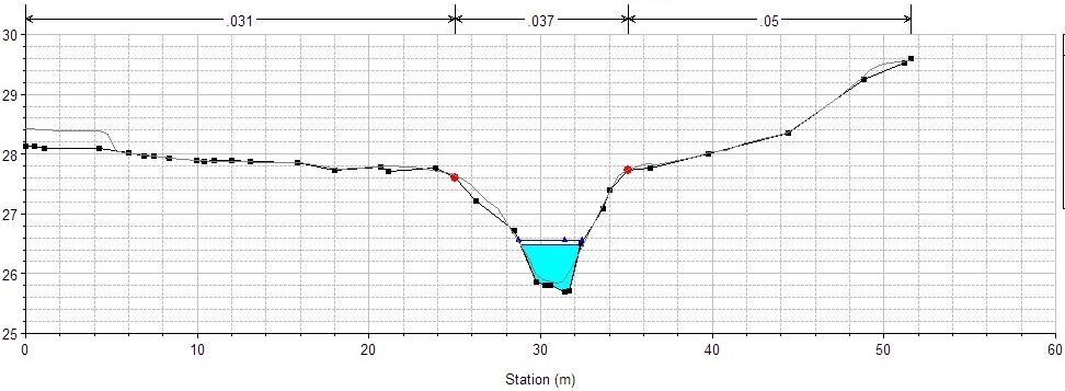
    This is straightforward where there is an embankment (i.e. the 2D area can be drawn along the crest); however, this does not apply for much of my river (see XS below).

    The manual states “try to find the high ground the separates the main river from the floodplain”. My feeling is to draw the 2D boundary just outside the bank stations. I’d appreciate other users’ feedback on this. Thanks!
    #10922
    cameron
    Participant

    For this cross-section I would say it is safe to draw it just outside the banks

    #10923
    Igloo_79
    Participant

    Thanks for your reply Cameron. This would mean that some of the 1D XS will overlap with the 2D Flow Area (and Lateral Structure). I’ve seen posts recommending avoiding such overlap, albeit without explaining the reasoning for doing so. (It will be time consuming to crop so many XS.) What is your view?

    #10924
    Anonymous
    Guest

    If you overlap the 2D area and don’t crop the XS, then you are double accounting the flow. The 1D model will convey flow in the overbank area and the 2D model will convey additional flow in the same overbank location. Adding blocked obstructions is probably quicker then deleting station/elevation data.

    When you connect the Lateral Structures, you will probably want to select “Normal 2D Equation Domain” and not “Use Weir Equation”. There isn’t really any levee or “high ground” between the channel and overbank. The 2D equation tends to be more stable for this situation than the Weir Equation.

    #10925
    Igloo_79
    Participant

    Many thanks for the info. I have not used obstructions before. Presumably, the elevation should be set to an arbitrary level above which no water could flow? My feeling is that cropping the XS may be a ‘cleaner’ approach.

    #10926
    Anonymous
    Guest

    Yes, the blocked obstruction needs to be set high enough to not get flow.

    Nothing wrong with cropping the XS.

    If the 1D is all properly geo-referenced then:

    In 5.0.3, it is easy to cut 1D cross sections from the terrain. So adjusting the 1D cross sections cut line in the geometry editor (so that the cross sections start or end right at the edge of the 2D area) and then cutting new cross sections might be a good approach.

Viewing 6 posts - 1 through 6 (of 6 total)
  • You must be logged in to reply to this topic.