Welcome to the RAS Solution › Forums › HEC-RAS Help › Unusual 1D-2D results – model not running in 1D?
- This topic has 6 replies, 654 voices, and was last updated 8 years, 3 months ago by Igloo_79.
-
AuthorPosts
-
November 9, 2017 at 9:08 pm #6680Igloo_79Participant
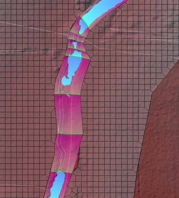
Hi – I have built a 1D model linked to 2D flow areas throughout using a number of Lateral Structures using procedures in the manual (Lat Structures: Normal 2D Equation + weir coefficients=0.2 to 0.28 SI units i.e. non-embanked channel). Reviewing the results (max depth), I noticed that the channel appears ‘dry’ in places where there are high elevation features in the channel terrain, thus acting as a barrier to flow. No results can be viewed in the XS viewer or summary tables. (Note that the 2D Flow Areas do not cover the channel and are connected to the ends of the 1D XS. 1D XS Interpolation Surface is shaded in pink for reference.)
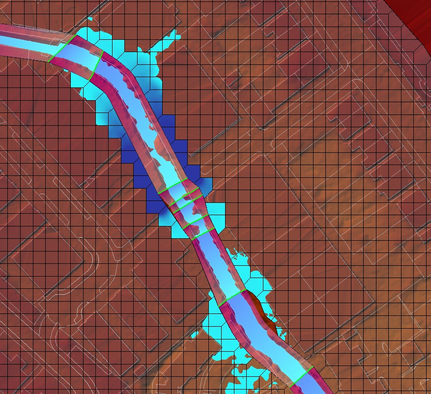
Also, there are ‘gaps’ between wetted 2D cells where the 1D channel is not fully wetted (image 2).
This leads to me think that somehow the channel flow is being modelled over the terrain somehow (instead of the 1D XS) / there is an issue with the 1D-2D link?! Feedback appreciated!
November 13, 2017 at 8:44 pm #10997AnonymousGuestHi Igloo_79
I used to have the same issue when i was using a terrain not modified.
To me, your terrain data in the main channel is wrong.
It is just a display bug.
You should see the 1D sections filled up as the flow is going in 2D area (so your Lateral Structures are consistent).
If the WSE isn’t higher than the ground, RAS Mapper doesn’t display any results.So if you wish to have consistent results in RAS Mapper, you should modify you terrain with 1D sections using XS Interpolation Surfaces.
November 13, 2017 at 8:57 pm #10998Igloo_79ParticipantYes, I think you’re right – the WSE is below the terrain elevation at these locations(!) Thanks.
As it is a long river (8km), I am reluctant to modify the entire channel terrain as it will result in some loss of detail from the DTM, so I may just do this at locations where the channel appears ‘dry’ in Mapper.
November 14, 2017 at 12:37 am #10999AnonymousGuestYes, you right, that’s the point.
You lose detail at the banks. So be careful with that.
I would do the same but i’m affraid you have to modify your whole main channel.
If you don’t want to do that, you just need to know that correct 1D section results are from the XS.
Defining the elevation banks correctly is very important in 1D/2D model coupled by LS in order to have consistent results.
November 14, 2017 at 1:39 pm #11000Igloo_79ParticipantMy intention was to create a new 1D geometry file only containing XS for the channel sections where I want to modify the Terrain (not tried it yet, though).
Defining the elevation banks correctly is very important in 1D/2D model coupled by LS in order to have consistent results.
Can you give some more details please? I am happy the 1D bank stations are set appropriately and have aligned the LS/2D Flow Area boundary to the end of the XS and along the high ground separating the channel.November 15, 2017 at 7:34 pm #11001AnonymousGuestThere are 2 work arounds that i would look into…1 i would suggest for after because itsmore advanced and i dont know the final product you want here.
The other one is to open each cross section in the geometry data editor and click at the top right “Plot Terrain (if available)
Make sure your cross section is exactly like the under lying terrain. If not click the button to update cross section based on the terrain. If you need the channel to stay the same the minimum step required would be to update the banks to the end of each cross section so you know 100% the 2D model and the 1D cross sections are at the same elevation. Then check your weir connection between the cross sections to the 2D area. Dierection from and to are very importnt
November 16, 2017 at 5:39 am #11002cameronParticipantYou can export out your 1D cross-sections as a terrain in Mapper. You can then create a terrain using the channel surface and the other terrain to create a combined terrain.
The 1D terrain export allows for the entire cross-section or just between the bank stations. If you turn on the XS interpolation layer in Mapper, you will see what the terrain will cover (not the elevation values). In some cases you may need to create interpolated cross-sections to make a better interpolation layer.
-
AuthorPosts
- You must be logged in to reply to this topic.

