Welcome to the RAS Solution › Forums › HEC-RAS Help › too high values at WSE compared to measured values in an 2D area
- This topic has 3 replies, 127 voices, and was last updated 5 years, 8 months ago by mistral.
-
AuthorPosts
-
June 16, 2020 at 2:54 am #7693mistralParticipant
Hello friends,
maybe someone could help me, this would be great.
I´ve made an flood simulation for an 2D flow area.
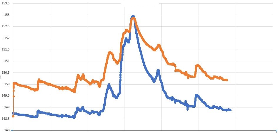
My problem is, that my in HEC-RAS computed values are about 5 ft. (1.5 metres) to high, compared to the real (measured) values. I have tried several time steps, 5 seconds, 30 sec …. 15 min, no improvement.
Friction slope an energy slope is set to 0.001.
My basic data from a gauge has WSE values for every 15 minutes for a period of 2 month. I took the WSE from my model at the same place, where the gauge is situated.
Am I doing sth. wrong? Do I need e.g. to include manning´s n in land cover layer?Thanks for your help .
(The diagram shows WSE (y axis) over a time of 60 days (x axis).
June 16, 2020 at 6:13 pm #12832cameronParticipantWhat is your roughness values? Is the water contained in the channel at all of the flows or is there flooding in the overbanks? Are you using the full momentum or diffusion wave solver? What is your cell size? How close is this location to one of your boundary conditions? It appears the comparison gets closer at higher flows, are you picking up the channel bathymetry correctly for low flows?
June 16, 2020 at 10:16 pm #12833mistralParticipant
What is your roughness values? Is the water contained in the channel at all of the flows or is there flooding in the overbanks? Are you using the full momentum or diffusion wave solver? What is your cell size? How close is this location to one of your boundary conditions? It appears the comparison gets closer at higher flows, are you picking up the channel bathymetry correctly for low flows?
Hello cameron and thank you very much for your answer.
“What is your roughness values?”
–>I used the default Manning´s n Value (0.06)“Is the water contained in the channel at all of the flows or is there flooding in the overbanks?”
–>During the flood the water flows overbanks (in the real flood and during simulition).“Are you using the full momentum or diffusion wave solver?”
–>I used the diffusion wave solver.“What is your cell size?”
–>My cell size is 100 metres (about 330 ft)
–>The Length of the whole Model is about 9 km (5.6 miles).“How close is this location to one of your boundary conditions?
–>The distance from the point where the water level was measured (at gauge house), and also the computed WSE was taken from, to the upstream BC is 8 km (5 miles).
–>The distance from the measuring point to the downstream BC is is about 1 km (0.6 miles).“are you picking up the channel bathymetry correctly for low flows?”
–>I have an digital terrain model which is pretty exact I think, if it is what you meant.thank you
mistral
June 17, 2020 at 1:44 am #12834cameronParticipantI would lower the roughness values for the channel to something more reasonable. I would reduce the cell size near the channel so you have at least 2 cells across the channel.
If you perform adjust the downstream boundary condition does it impact the results significantly?
I was just making sure that the terrain you are using picks up the channel inverts and not just based on LiDAR which would have the wse elevation and not the inverts.
If you cut a cross-section at the location of the gage and do a simple manning’s calculation on the capacity for a few different discharges, does the wse match the gage?
Does the gage datum match the vertical datum of your terrain?
-
AuthorPosts
- You must be logged in to reply to this topic.
