Welcome to the RAS Solution › Forums › HEC-RAS Help › Terrain not visible in geometric data window
- This topic has 12 replies, 8,960 voices, and was last updated 9 years, 7 months ago by cgarner.
-
AuthorPosts
-
August 29, 2016 at 12:20 am #6183cgarnerParticipant
I successfully created a new terrain (~4.5GB) from a 1m LiDAR dataset in RAS Mapper. I then exported the terrain to image. I can see the terrain image listed in “Select layers to view in background” but when checked I am unable to view the terrain as image in the geometric data window. I’d prefer to view the terrain as shown in the Mapper but that checkbox doesn’t seem to work for me either. I tried some of the solutions I found on the forum (e.g. set schematic plot extents, panning, etc.):
http://hec-ras-help.1091112.n5.nabble.com/Background-Imagery-td2303.html#a2307
but could not use those solutions to resolve the problem.
The project is in SI units, has a projection, and the terrain is associated with the geometry. Everything plots fine in RAS Mapper.
Thinking it might be the size of the terrain I repeated the process in a new project with a smaller chunk of the LiDAR dataset but I am experiencing the same issue.
I have posted the project (~800 MB) here:
https://www.dropbox.com/s/9s9jds7thbwlpgr/SubsetLiDAR.zip?dl=0
I am also not able to view the GIS world imagery in the geometry window. It shows up in RAS Mapper.
If anyone here can help me figure out how to get the terrain or terrain image to display in the geometry window it would be greatly appreciated.
Thanks,
ChrisAugust 30, 2016 at 8:30 pm #10033AnonymousGuestHowdy,
Here are a few thoughts:
– You are right about the size limitations, I have heard there is a ~4GB limit to terrain data….
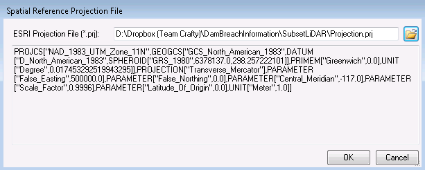
– In the drop box folder there is no projection file. Make sure its the correct *.prj. Is it UTM? I have seen some weird stuff with UTM USft.
– I had issues with the conversion of projections in HEC when creating a terrain for my project. Try creating a terrain with no spatial reference selected…just ignore the warnings! Only do this if you know for sure your TIFF is in the right projection to begin with. Once the terrain is created then add you spatial reference back. Also, make sure you terrain has a no data value.
Good luck.
August 31, 2016 at 1:21 am #10034RasL DazLParticipantHi Toby,
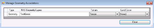
Thank you for your suggestions. I created the terrain in RAS Mapper from a tif that I exported from the LiDAR in ArcGIS. When I imported the tif and created the terrain I skipped assign projection because the tif already had a projection (NAD 83 UTM Zone 11). I did run into the no data issue and had to assign the no data value in order to import the terrain. The geometry is associated with the terrain:
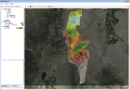
After terrain generation and export terrain to image everything displays in the correct location in RAS Mapper as verified by ArcGIS Web Imagery:
I will be performing a dam breach study and I believe the model will require combined 1D/2D modeling. The project is starting up soon so I’m trying to get myself up to speed fast. Its impossible to digitize 2D mesh into the the geometry at the correct location when you can’t see the terrain or land surface.
The project I posted earlier was referencing the projection file in a different directory on my local machine.
I have updated the project on Dropbox to include the projection file
(Projection.prj in NAD 83 UTM 11) and reposted the files:https://www.dropbox.com/s/i8w8x5uovm4oe2f/SubsetLiDAR.zip?dl=0
If you redownload and see the problem I having, you should be able to view the terrain in RAS Mapper, but not in the geometry window. I am totally stumped and just need to get to model building.
My previous registration for the blog didn’t go through correctly so I registered with a new name.
If you or others can find a few minutes and see if the terrain or image of terrain can be displayed in the geometry and potentially determine why it won’t display it would be very helpful.
Thanks,
RasL DazL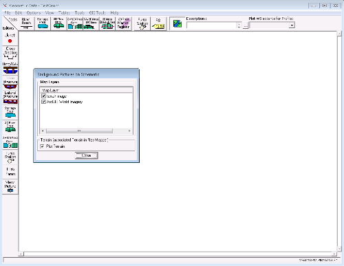
 August 31, 2016 at 8:12 pm #10035AnonymousGuest
Hey RasL DazL,
What version of HEC are you using? Worked on 5.0.1.
Your Terrain opens right up in my geometry window! No need to use the image version of your terrain, as its already visible and then you won’t have the black border. I got the images to load too in both the geometry and RAS Mapper windows. Online data took awhile to load in the geom window.
I might reinstall HEC-RAS.
cheers,
Toby
September 1, 2016 at 12:09 am #10036RasL DazLParticipantHey Toby,
I tested the project on another machine and it worked as you described. I tried the reinstall on my “fast” computer and it still wouldn’t display. I’m beginning to think that this is specific to my computer. Is your machine 64 or 32 bit? What OS are you running?
Thanks so much for looking into my issue,
ChrisSeptember 1, 2016 at 2:30 am #10037AnonymousGuestGlad your making progress. I’m running Windows 8.1 – 64-bit.
September 3, 2016 at 2:13 am #10038AnonymousGuestThere is not a ~4GB limitation for terrain data, as mentioned in this post. I have created and used RAS (.hdf) terrain files generated from GeoTIFFs exceeding 50 GB.
September 3, 2016 at 9:46 pm #10039cgarnerParticipantI have found the issue to be related to a specific user account (mine) on my machine. Local user account has not problem with terrain >4gb.
October 21, 2016 at 5:23 pm #10044AnonymousGuestYou simply need to right click on Terrains (on the group layer!, not the terrain you added) and then manage the terrain associations by clicking ok and finally choose the right terrain (if you have multiple) to be added to your geometry.
June 22, 2017 at 9:16 pm #10040AnonymousGuestHi! I’m having the same problem you described, the computed data extents doesn’t work… I’m running win 10 on a 64bit dell laptop…. Anyone knowing issues with win 10?
How can I solve?
Thanks in advanceP.S.: HEC RAS 4 has no issues of this kind on my laptop… so, what’s wrong with HEC RAS 5 on my machine?
June 23, 2017 at 1:13 pm #10041AnonymousGuestok, I got myself answered… In HEC-RAS 4 (and in previous HEC RAS 3.x) when you added background images in the geometry view it asked you to adjust plot extents to computed ones. Now it seems to not compute data extents, even if in Ras Mapper it is able to correctly zoom to layer… So, I put reach cut line coordinates in the table you can view from the geometry editor and then the schematic plot extents worked!
Hope this will help anybody!
Bye
September 16, 2019 at 1:46 pm #10042AnonymousGuestI am facing the same issue with my HECRAS 5.0.6 version ?Can you re-state the solution ?
January 25, 2021 at 4:19 am #10043almamhParticipantIn HEC RAS 5.0.6, in the geometry editor I clicked View > Set Schematic Plot Extents … > Set to Computed Extents. This worked well.
-
AuthorPosts
- You must be logged in to reply to this topic.