Welcome to the RAS Solution Forums HEC-RAS Help SA/2D Area conn problem

  • This topic has 4 replies, 440 voices, and was last updated 5 years ago by noila.
Viewing 5 posts - 1 through 5 (of 5 total)
  • Author
    Posts
  • #7434
    noila
    Participant

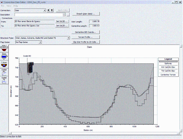
    My model runs fine with gated or time series outlets. But when I use a rating curve outlet the following message shows up:

    ERROR with Connection(s)

    The SA 2D Connection at Dam

    has a rating curve with a starting flow elevation lower than the cell
    it is connected to (this is not allowed in HEC-RAS):
    cell 18491 cell elev 693.73
    between Face Points 23739 23183
    for 2D Area Bacia do Iguacu

    I´ve already tried several different intervals for my rating curve. Next step would be try to change the 2D cells and bring them higher than the rating curve lower elevation. But I can´t see any way to do that with a SA/2D Area Conn. The HW and TW tabs don´t allow any changes. If anyone would be so kind to shed some light into this, I´d be very grateful!

    #12499
    ckatsoulas
    Participant

    From what I can see the cell (#18491) is too high for the rating curve you have provided. You are giving HECRAS a starting water level below the ground level. You rating curve needs to have higher elevations or your cell where it connects to the SA 2D connection needs to be lowered so that the starting water level has some positive depth.

    #12500
    Anonymous
    Guest

    Thanks for te insight!
    However, how could I possibly lower the cell connected to the SA 2D? Both HW and TW tabs don´t allow changes to be made to the terrain. What I did so far was trying different rating curves intervals, including with a starting flow elevation higher than all the cells connected to the SA 2D. I also changed the structure width for getting different cells elevation. Unfortunately, both solutions to no avail.

    #12501
    ckatsoulas
    Participant

    To lower the terrain you need to use a GIS software like QGIS. You create a polygon add an elevation field and set the required elevation. Then you burn the new level of the shape into the terrain using the ‘Mosaic raster’ option.

    #12502
    Anonymous
    Guest

    Copied that. Thanks again!

Viewing 5 posts - 1 through 5 (of 5 total)
  • You must be logged in to reply to this topic.