Welcome to the RAS Solution › Forums › HEC-RAS Help › Offline Storage Area
- This topic has 5 replies, 2,422 voices, and was last updated 12 years, 8 months ago by NDiGennaro.
-
AuthorPosts
-
May 29, 2013 at 10:14 pm #5283NDiGennaroParticipant
Hello, I’ve read through, and searched the forums, so I don’t believe this topic has been covered yet, my apologies if it has. And if it has, if you could please direct me to the discussion, that would be greatly appreciated.
So here’s the project… We have a HEC-RAS model of a creek, runs great. However, offline, but in the floodplain of the creek is a lake. The creek can flow into the lake, once it reaches a certain depth. I can model that as a lateral structure between cross sections going to a defined storage area. Then, a little bit further downstream in the creek, the lake has an outlet point which will rejoin the creek. I was hoping to use another lateral structure to tie the lake back into the creek, but that doesn’t seem possible? If it is, let me know. But here are my other thoughts on the matter.
The way to do it would be to create a separate short reach, starting at the discharge point of the lake, and tie it into the creek. Or even model the whole lake as a reach with cross sections, separately from the creek. The creek and lake are separated by maybe 100ft, and so there isn’t a whole lot of storage above the lake to model. So creating a reach and cross section model for the entire lake would make for some very shallow cross sections, which HEC-RAS isn’t so found of computing.
Another option is to take the outflow from the lateral structure that represents the inflow area to the lake, and plug it into a HEC-HMS or HydroCAD model, with the lake and the outlet modeled in there, then take the outflow curve from that model and plug it in as a lateral inflow in HEC-RAS at the downstream cross section of the creek.
As the model stands now, the cross sections of the creek just go right over the lake, with some higher Mannings’ n values, but it’s not showing the proper water surface elevations. It ends up showing the lake dropping 10ft from upstream to downstream edges. Obviously, that’s not what’s happening. While this is a very tempting case for 2D modeling, we would prefer to steer clear of that for various reasons.
Suggestions? Comments? Questions? I’d love some feedback on this please. Thank you!
Civilly,
Nicholas DiGennaroMay 30, 2013 at 2:45 am #8409JarvusParticipantDo you need to model the section between the output of the lake and the creek? If the answer is no, then I would put a second lateral structure (LS) at the downstream end where you want it to flow back into the creek and connect that LS to the storage area and use the lateral structure to model the outlet point.
If you want to model the section between the lake outlet and the creek, I would probably create a new reach. The upstream end of this reach would connect directly to the storage area. The downstream end of the reach would connect to the creek with a junction. You would probably want to add an inline structure to represent the outlet of the lake. If you take this approach, the reach between the storage area and the creek has to stay wet in order for RAS to run. A tiny flow and/or tiny pilot channel would suffice.
Or yes, you could represent the lake as a series of cross sections (instead of a storage area) if you felt it needed it.
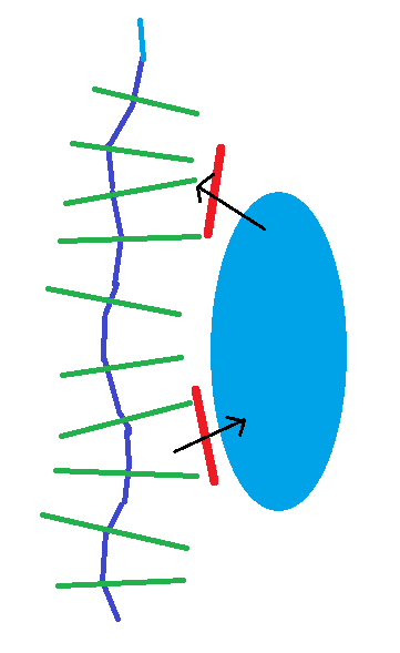
June 1, 2013 at 1:04 am #8411Chris G.KeymasterYou absolutely can model in and out of a storage area using two lateral structures in unsteady flow RAS. Both lateral structures will be placed in the creek. Their tailwater locations will be the storage area. Flow will be able to go both directions over both lateral structures. If it flows from the storage area to creek, it will be listed as negative flow. I’ve done this many times…it works. The figure below is a crude example of the simplest way to do this. You could also model the offline area as a separate reach, also connected to the main creek by two lateral structures.
June 11, 2013 at 6:07 pm #8410AnonymousGuestNo, I do not need to model the reach between the lake outlet and the main reach channel. The outlet channel reach is already accounted for in the cross sections of the main channel reach (it’s in the floodplain anyways).
Currently, that is how I have it modeled (two reaches), but I’m going to adjust it to use two lateral (inflow and outflow) structures for the pond. I think that makes more sense for what I’m interested in.
Thank you for your response! It was very helpful.
Civilly,
Nicholas DiGennaroJune 11, 2013 at 6:12 pm #8412AnonymousGuestAhhh, ok. That’s what I was concerned about. If HEC-RAS saw the lateral structure I set as the outlet control section of the lake, and then gives me negative flows. I was worried it wouldn’t handle it and throw a hissy fit. But it does work, it just takes a little bit extra brain power reading through the output tables to understand what is going on.
Thank you for your response! It was very helpful. The diagram you sketched up is EXACTLY what I’m trying to do.
Civilly,
Nicholas DiGennaroJune 11, 2013 at 9:38 pm #8413Chris G.KeymasterGreat!
-
AuthorPosts
- You must be logged in to reply to this topic.
