Welcome to the RAS Solution › Forums › HEC-RAS Help › How does RASMapper create 2D maps for 1D models?
- This topic has 3 replies, 94 voices, and was last updated 5 years, 7 months ago by Geo_Wick.
-
AuthorPosts
-
August 22, 2020 at 3:27 am #7736Geo_WickParticipant
I feel like I am missing something very basic, but I just can’t wrap my head around it.
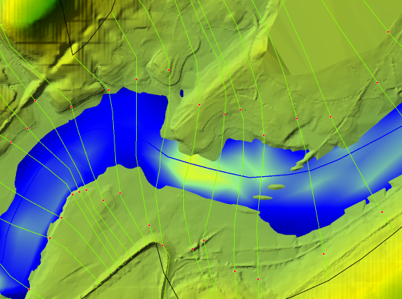
How does RASMapper take a 1D model, and provide a 2D map of, for example, velocity? Like in the screengrab below, which is a velocity profile, how does RASMapper interpolate velocities between cross-sections? It doesn’t appear to be straight interpolation, but it’s hard to tell since cross-sections are almost never uniform.
Depth, I can understand how mapping that in 2D is possible by simply assuming a “flat,” consistent water surface between cross-sections, then subtracting the ground elevation given by the terrain. But how does that happen for velocity?
If you were working with a model that you do not have terrain data for, i.e. you manually inputted the elevation data for each cross-section, what would RASMapper do then? Assume a “flat,” consistent terrain/river bottom between cross-sections, producing a much more uniform and obviously interpolated map for depth?
Thanks in advance for any insight!
 August 23, 2020 at 4:27 am #12911JarvusParticipant
For velocity mapping of a 1D model in RASMapper: if you are asking if it takes into account the underlying terrain between two cross sections, I do not believe so.
Each 1D cross sections gets a velocity distribution along the cross section. If you open up the geometry editor and click the HTAB button, there are columns for the number of horizontal velocity slices. So by default the channel would be sliced into five equal top widths and a velocity computed for each slice using the conveyance computed from Manning’s equation.
RASMapper knows the location of the stream center line, the location of the channel banks and the location of the ends of the cross section. I believe it uses this information to curve the velocity for the static velocity arrow or for the dynamic velocity tracing.
So I think the magnitude of the velocity is basically a straight interpolation along a stream path. For instance, the stream path that is just inside the left channel station. The location of this stream path and the direction of the velocity arrows is based on some combination of channel center line and bank locations.
Depth I think it does look at the underlying terrain, which as you point out is pretty straight forward. Although I could quibble slightly with calling it flat. I would suppose that the water surface elevation is linear interpolated along a stream path.
I have not tried it, but I was not aware that you could get RASMapper plots like depth without a terrain file.
August 24, 2020 at 5:59 pm #12912cameronParticipantYou have to have a terrain to get any results that make sense in Mapper.
The program uses the interpolation surface created from cross-sections to plot the wse on the terrain. It should also use the same surface for velocity based on the slices mentioned above along with the bank lines layer in Mapper.
You can manually modify the interpolation surface by adjusting the edge line layer and recomputing the interpolation surface. You can also manually adjust the bank lines layer in Mapper as well.
August 24, 2020 at 8:55 pm #12913Geo_WickParticipantThank you for the explanations, cameron and jarvus, this makes a lot more sense now!
-
AuthorPosts
- You must be logged in to reply to this topic.