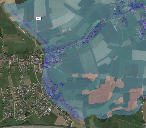
Hello,
i got an offset between the google satellite web imagery and my dgm in RAS-Mapper and cant figure out how to solve it:
The dgm should be in EPSG31255 (MGI / Austria GK Central).
When i load it in QGIS the info says:
Unbekanntes KBS: PROJCRS[“GK-M31”,BASEGEOGCRS[“MGI”,DATUM[“Militar-Geographische Institut”,ELLIPSOID[“Bessel 1841”,6377397.155,299.152812797403,LENGTHUNIT[“metre”,1]]],PRIMEM[“Greenwich”,0,ANGLEUNIT[“degree”,0.0174532925199433]],ID[“EPSG”,4312]],CONVERSION[“Transverse Mercator”,METHOD[“Transverse Mercator”,ID[“EPSG”,9807]],PARAMETER[“Latitude of natural origin”,0,ANGLEUNIT[“degree”,0.0174532925199433],ID[“EPSG”,8801]],PARAMETER[“Longitude of natural origin”,13.3333333333,ANGLEUNIT[“degree”,0.0174532925199433],ID[“EPSG”,8802]],PARAMETER[“Scale factor at natural origin”,1,SCALEUNIT[“unity”,1],ID[“EPSG”,8805]],PARAMETER[“False easting”,0,LENGTHUNIT[“metre”,1],ID[“EPSG”,8806]],PARAMETER[“False northing”,-5000000,LENGTHUNIT[“metre”,1],ID[“EPSG”,8807]]],CS[Cartesian,2],AXIS[“easting”,east,ORDER[1],LENGTHUNIT[“metre”,1,ID[“EPSG”,9001]]],AXIS[“northing”,north,ORDER[2],LENGTHUNIT[“metre”,1,ID[“EPSG”,9001]]]] – Projiziert
and as raster: 0.500000000000000222,-0.500000000000000222 meters
I did some work in QGIS to set up the model area and so i transformed it to EPSG31255 KOS.
When i load it in the RAS-MAPPER with the projection file EPSG31255 (from spatial reference.org) the offset as in the image appears (its the same in land use data and dgm).
I hope you can help as it is very important for my master-thesi, thank you.
