Welcome to the RAS Solution › Forums › HEC-RAS Help › Flood Map
- This topic has 25 replies, 1,234 voices, and was last updated 10 years, 12 months ago by Anonymous.
-
AuthorPosts
-
April 22, 2015 at 12:45 pm #9262neeyoleParticipant
My topographic data is based on a DEM with 2 m resolution and I was exporting the geometric data con GeoRas. Yeah they matched quite well and also the imagery has a really good resolution.
April 24, 2015 at 7:04 am #9263cameronParticipantWhat was the DEM created from? Have you compared the DEM to other elevation data sources to verify if it makes sense? Google Earth is a easy source to see if the terrain is roughly the same.
April 24, 2015 at 1:27 pm #9264neeyoleParticipantI got the 2 m resolution DEM from the Centre for Environmental Data Archival and also a 5 m resolution DEM from another agency and they matched. I just checked Google Earth as you suggested and seems to make sense. I created the Tin from the DEM, there may something wrong with that?
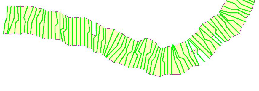
April 27, 2015 at 10:31 pm #9265jadamsParticipantI noticed from your image that it looks like if you mirrored the topographic information the banks would be in the correct locations. You must draw streams in GeoRAS from upstream to downstream AND you must draw cross sections from Left to Right as facing Downstream. I would guess that you may have drawn them the opposite way. If all your sections are this way you can reverse the cross sections in RAS. Do so by left-clicking the section in the geometry editor and say reverse direction. You can graphically see what RAS thinks is the left side of the section by where the label is located, it is generally on the left side. Also you can see: Reverse Sections Link for more information.
April 28, 2015 at 1:06 pm #9266neeyoleParticipantHi Jadams,
Thanks a lot for your response. I think that the idea you suggested is quite unlikely since I used the GeoRas tool by which the cross sections are drawn automatically. I got some advice from an Hydrologist and he said it has to do with the accuracy of the DEM that even though it has a really good resolution (2m) maybe not enough to extract an small stream.
But anayway thanks a lot for your tipsMay 19, 2015 at 9:23 pm #9267neeyoleParticipantHi guys,
After a lot of work I realized Cameron was right about the DEM. Simply, the way of the creation of the TIN was not the correct one. So any similarity with the reality was fiction. I’ve already managed to do it correctly by creating the TIN from the contour lines and points with the Z value extrapolate from the DEM instead of using the tool from raster to TIN that was causing so many problems. Only say thanks and I hope that this information can be useful for someone else in the future.
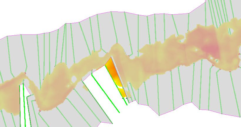
I would also like to ask if someone has an idea about the error I am making in this boundaring Polygon that is the result of importing the data from HEC-RAS to GEO-RAS. Why is it not consistent throughout my TIN?
Many thanks
Laura
 May 20, 2015 at 2:46 am #9268cameronParticipant
Do you have levees in your model? Levees adjust the boundary polygon like you have shown.
May 20, 2015 at 12:57 pm #9269neeyoleParticipantHi Cameron,
Thanks a lot for your quick response. I do have leeves but I didn´t know that the leeves cut the bounding polygon like that because I have that part (see pic attached) as well where you can see the water is passing through the levee and there are some patches that´s why it was a bit confusing. What am I doing wrong?
 May 20, 2015 at 3:12 pm #9270userParticipant
It seems odd that you have some water outside your bounding polygon. Have you verified that your cross sections are placed correctly ?
May 20, 2015 at 7:20 pm #9271cameronParticipantWas the result grids based on the bounding polygon shown or something else? Normally no water should be displayed outside of the bounding polygon.
Have you tested looking at the results in HEC-RAS 5.0 in the Mapper? It is far easier than using GeoRAS.
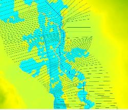
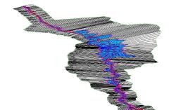
May 21, 2015 at 8:55 pm #9272neeyoleParticipantIt was the same bounding polygon. I just did and the results and getting worse and worse. I can’t find any explanition about that:
1. Snapshoot from Ras mapper ( as you can see the wáter Surface is not even continuous and it happens along all my river)
2. Snapshoot from View 3D multiple cross section (any water is being displayed outside my levee!!)
PLease help I am starting to be desperate
-
AuthorPosts
- You must be logged in to reply to this topic.