Welcome to the RAS Solution › Forums › HEC-RAS Help › Flat Water Profile
- This topic has 10 replies, 841 voices, and was last updated 8 years, 8 months ago by dpatterson12.
-
AuthorPosts
-
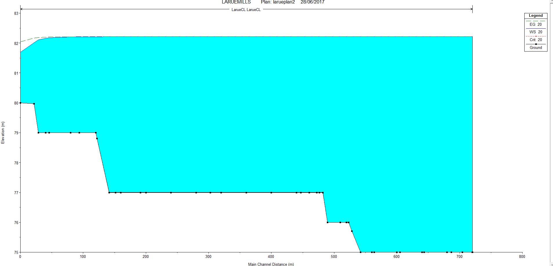
June 28, 2017 at 9:00 pm #6516dpatterson12Participant
Hi Everyone!
I have run into a problem with my model. I am performing a steady state flow model and found my resulting water elevation is consistent throughout the whole profile. Is there any way to fix this? Mannings 0.040. Basically the water profile is flat and should have a slope.
I hope someone can help.
 June 29, 2017 at 2:23 am #10669TobyParticipant
Your river direction is backwards. In RAS station 0 is the downstream station. You can see what looks like a normal depth BC at station 0. So water has to fill the cross sections, like it would in a lake, before spilling out. Hope this fixes it for you.
June 29, 2017 at 4:33 pm #10670dpatterson12ParticipantThe Downstream station position is correct. I reversed the order and the results didnt change.
June 29, 2017 at 5:35 pm #10671gustbadellParticipantThe water profile seems to be correct considering flow direction and terrain profile, I would understand you are modeling a reservoir. The velocity is near to zero in the whole profile except at the oulet
June 29, 2017 at 7:26 pm #10672dpatterson12ParticipantI have tried it with other test channels and i am receiving the same result. As if it is not draining.
June 30, 2017 at 2:12 am #10673TobyParticipantIf the direction if flow is correct (eg water is flowing uphill), what is your inflow?
You may want to use the unsteady engine and run your inflow hydrograph as a “fake” steady state in the unsteady flow editor. Then run your model over a time window and see if water level changes. Right now your WSE is sloped at the downstream end, but you expect that to translate upstream further is what I am guess you are thinking.
July 5, 2017 at 4:54 pm #10674dpatterson12ParticipantHi,
Sorry for the late response.
My Direction is from 0 to 400+. I have tried reversing the direction of the alignment and reversing inverts. Nothing has changed the direction of flow. Is there a way to set a station as the downstream end, because it appears hec ras will keep making station 0 the downstream end.
Sincerely,
David
July 5, 2017 at 4:54 pm #10675dpatterson12ParticipantHi,
Sorry for the late response.
My Direction is from 0 to 400+. I have tried reversing the direction of the alignment and reversing inverts. Nothing has changed the direction of flow. Is there a way to set a station as the downstream end, because it appears hec ras will keep making station 0 the downstream end.
Sincerely,
David
July 5, 2017 at 5:31 pm #10676AnonymousGuestThe sign convention adopted in HEC-RAS has positive flow going in the direction of decreasing station ID. If you want flow to go from small to large stations, make it negative.
July 5, 2017 at 8:47 pm #10677dpatterson12ParticipantThanks for the help! So my numbers have improved at least with relation to elevation, but still no dropping water elevation. I have attached a link for the files.
https://drive.google.com/drive/folders/0B-eURNN6b9OkWTlDR1hmYjRYbHc?usp=sharing
THanks everyone! we are getting there.
July 6, 2017 at 5:12 pm #10678dpatterson12ParticipantSOLUTION!
Thank you for your help i tried some of you suggestions with a new file and it worked great. So first if you are using CAD make sure your station 0 of you alignment is at the down stream end with stations going upstream. Then once in HEC-RAS go to Geometry editor-GIS Tools-Reach Invert Line Tables-reverse order (to make sure your arrow in HEC-RAS is point downstream toward station 0). Then run your analysis.
A little counter intuitive, HEC-RAS needs to make there station controls easier to control.
Thank you everyone for your help!
-
AuthorPosts
- You must be logged in to reply to this topic.