Welcome to the RAS Solution › Forums › HEC-RAS Help › Error writing geometry; Unable to compute face tables
- This topic has 11 replies, 1 voice, and was last updated 2 years, 10 months ago by Javier Valdes-Abellan.
-
AuthorPosts
-
April 20, 2016 at 10:37 pm #6063OgwskiParticipant
I have a one dimensional steady state model of a river and I’m trying to run a two dimensional with steady flow simulation of the same river in 2D with the HEC-RAS 5.0. So, I was working with the geometry, and getting used to the RAS Mapper, but when I try to run the 2D simulation I get this error:
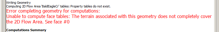
Writing Geometry
Computing 2D Flow Area ‘BaldEagleCr’ tables: Property tables do not exist.
Error completing geometry for computations:
Unable to compute face tables: The terrain associated with this geometry does not completely cover the 2D Flow Area. See face #0Does anyone knows what does it mean?
I did associate the terrain layer with a geometry file like the manual said I should, but the same error persisted, then I tried to run one of the exemples (Bald Eagle) to see if I was missed something, but nothing.
Thank you!
 April 21, 2016 at 2:06 am #9861Vince MoodyParticipant
A quick pedantic note: 2D simulations are inherently unsteady. You can use a constant inflow hydrograph, but review Chapter 6 of the 2D Modeling manual for additional discussion.
Within RAS Mapper, does your 2D Mesh line up with your Terrain (i.e. same projection)?
Within RAS Mapper, if you right click the 2D Area layer under your geometry and select “Compute 2D Area Hydraulic Tables”, what happens?April 21, 2016 at 7:05 pm #9863cameronParticipantThe error states that your terrain file does not cover the 2D boundary. Is your terrain file larger than the 2D boundary extent?
April 21, 2016 at 7:53 pm #9862OgwskiParticipantHi, thank you Vince and Cameron.
Q: Within RAS Mapper, does your 2D Mesh line up with your Terrain (i.e. same projection)?
A: So far everything tells me that yes. Even on the Bald Eagle example I get this error.Q: Within RAS Mapper, if you right click the 2D Area layer under your geometry and select “Compute 2D Area Hydraulic Tables”, what happens?
A: I get this warning:I guess I have a problem with my projection like you said. I’ll work trying to solve this now!
Q: The error states that your terrain file does not cover the 2D boundary. Is your terrain file larger than the 2D boundary extent?
A: I don’t know how to answer this because even with the Bald Eagle example I get this error, are the demos are purposely defective?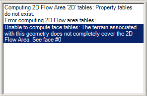 August 18, 2016 at 12:43 am #9864AnonymousGuest
I had the same error but found that there was a missing patch in my ground model within the 2D area. It was quite a small area but stopped the geometry info process at the start of the run.
August 18, 2016 at 1:16 am #9865OgwskiParticipantHi Paul,
I forgot to update the topic; but the problem was exactly what you described.
Thank you!
October 25, 2018 at 11:24 pm #9866AnonymousGuestHi
In case someone faces the same problem in future, I solved my problem by editing the 2D area by making sure that its boundary is not close to the edges of the terrain.
May 2, 2019 at 3:05 pm #9870dais davyParticipantwe are facing what to do next?? pleasee help
 May 2, 2019 at 3:16 pm #9868dais davyParticipant
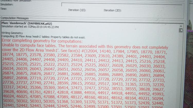
Error completing geometry for computations: unable to compute face tables. the terrain associated with this geometry does not completely cover the 2D flow area ‘mesh’
this is our error. please help us, we are having an important presentation tommarow. pleade help us
 May 2, 2019 at 4:44 pm #9869AnonymousGuest
Hello,
please check if your grid is “smaller” then your terrain. Your computational grid must be all inside of your Terrain data. Please, check cameron and Talia’s answer. I solved this problem using their methodology.
If your problem is different from this, I can’t help you.
May 2, 2019 at 5:17 pm #9867dais davyParticipantface table error is occured only on certain coloured parts(yellow and pink in terrain)
how to slove thoseeApril 20, 2023 at 3:59 am #17493Javier Valdes-AbellanParticipantHello all,
Just to add an additional piece of information that may help someone in the future.
I faced the same problem that dais davy reported when I modified an original terrain under the methodology of including some modifications by creating a fake geometry, exporting it as a terrain and later combine the original terrain with the new one containing the modifications.
I solved it by using the option of right-click on the new terrain that combines the original one and the modificaitons\Generate New RAS Terrain\Resample to single terrainI hope this may help.
Javier -
AuthorPosts
- You must be logged in to reply to this topic.