Welcome to the RAS Solution Forums HEC-RAS Help Combine model 1D/2D

Viewing 5 posts - 1 through 5 (of 5 total)
  • Author
    Posts
  • #6303
    sarceh
    Participant

    Hello!
    I’m working on a small river reach just 300 m long and I’m trying to connect main channel (1D) to left and right flood area (2D). I managed to connect it together, using lateral structure. The simulation seems to be stabile, but it pops this out:

    Maximum 1D/2D iterations:
    20SEP 12:15:17 River River 0 337
    20SEP 12:15:17 River River 1 337

    This message goes on for my river station 337 and 338, where is the station of my lateral structure. Can be problem for this in my lateral structure??
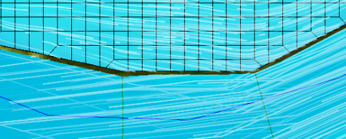
    As I was saying, the simulation went trough. And if I look at the results in RAS MAPPER I see the water transfering from main channel to flood areas, but on some sections on the river there are gaps with no flow in it. Is this only visual problem or my water really does not flow on that areas? Because the connection between 1D/2D is ok, I can see the thick black line witch means that connection was made. Is the problem that my profiles are not in the 2D mesh area (my profiles end a little bit before the 2D mesh beggins)?

    Here is the picture of that gap between main chanel and overbank, right were the lateral structre is:

    Thank you

    #10301
    cameron
    Participant

    the the cross-sections, lateral structure, and 2D model boundary overlay exactly on top of each other? It does not appear that it does based on the image you provided. HEC-RAS creates a interpolation layer (see RAS Mapper) that it uses to generate the 1D results which if does not touch a 2D area means there will be a gap. The only way to fix this is make sure the layers are right on top of each other. In some cases you will need to add more cross-sections to get it to match up if the river meanders between cross-sections.

    #10302
    Anonymous
    Guest

    Thank You!
    yes it is true. my layers don’t overlay exactly on top of each other. i tried to fix it but it seems that i’m do it wrong. do you have some quick tip how to create that my 1D and 2D model will touch? i import my geo file with cross sections and than in Mapper I create the terrain and the picture of it. than I create in geometry window my 2D area, but is there some detailed way to define it? I just zoom very close to the end of cross section and define my 2D area. This way is very lose. Can I do that any other way?

    Thank You very very much

    #10303
    cameron
    Participant

    I usually set up the model in GIS and snap everything together. If you already have a model, you can export out the layers to GIS and adjust them before bringing them back into HEC-RAS. If you are zooming in close like you say, that should get rid of the gaps as well if done right.

    #10304
    Anonymous
    Guest

    Thank You!

Viewing 5 posts - 1 through 5 (of 5 total)
  • You must be logged in to reply to this topic.