Welcome to the RAS Solution › Forums › HEC-RAS Help › Arithmetic operation resulted in an overflow error?
- This topic has 6 replies, 1,399 voices, and was last updated 8 years, 9 months ago by hrasuser12.
-
AuthorPosts
-
May 5, 2017 at 5:26 pm #6455hrasuser12Participant
Hello,
My name is Colin and I’ve been having an issue with my HEC model. Anytime I try to do a steady flow analysis run I keep getting this issue: Error generating interpolation surface, Arithmetic operation resulted in an overflow. I was wondering if anyone could help me figure out what’s causing this error to appear?
Some background: I received this project from FEMA and it wasn’t georeferenced at all, the river was in a straight line and all cross sections and bridges were perpendicular to the river. It was in meters and I converted the units to English units, and I have this as the first plan called: final existing conditions w/100yr MO Riv. I did a steady flow run and it computed the model just fine without the error mentioned above. In the plan titled: Plan 02 I tried to clean up the FEMA model by georeferencing everything. I georeferenced the river by manually entering in northing and easting data into the reach invert lines table under GIS Tools and I had HEC-RAS automatically georeference the cross sections to be perpendicular to the new river, so all the cross sections have northings and eastings in the XS Cut Lines table in GIS Tools. So now Plan 02 looks the way I want it to look, but when I go to do a steady flow run, I get the error I mentioned above: Error generating interpolation surface, Arithmetic operation resulted in an overflow. The only thing that changed between the two plans was georeferencing. What could be causing this error?
I’ve created a shareable Google Drive folder that contains the project, so if you would like to actually download and see the model for yourself you have that option. It’s in the folder named: HEC-RAS Project Folder. I’ve enabled full editing options too so you can upload any changes you make to the project if that’s something you choose to do. (You’ll have to be logged into Google to upload I think). And you can upload your version of the project in the folder titled: Upload Edited Model Here. Just make sure to create a separate folder within that folder to keep your project separate from other user’s projects please
. Here’s the link to the project: https://drive.google.com/drive/folders/0B-mQamJ7bwbQV0dYMDZGLUNvalU?usp=sharing
Any information anyone can provide would be really appreciated!
May 5, 2017 at 5:53 pm #10563Jake GParticipantHi Colin,
I took a look at the geometry for Plan 02 and there are a number of intersecting cross sections. If you adjust the georeferencing so that the intersections are eliminated, it should get rid of the error HEC-RAS is giving when trying to generate the XS interpolation surface.
– Jake G.
May 5, 2017 at 6:01 pm #10564hrasuser12ParticipantJake,
Thanks for taking a look, I’ll go ahead and make that change and see if Plan 02 runs.
Also do you have any advice on how to adjust the cross sections cut lines so they don’t intersect? Does it matter if I make the XS Cut Lines smaller in length than the actual cross section?
May 5, 2017 at 7:22 pm #10565Jake GParticipantColin,
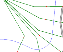
The main issue is usually the inside of a sharp bend. Here’s an example of a cross section layout in that case.
I wouldn’t recommend making the XS Cut Lines smaller in length than the actual cross section because by georeferencing you’re trying to get the cross sections as close to their actual location as possible, including their extents.
Since this was originally a FEMA model, there will likely be lettered cross sections on the Flood Insurance Rate Map that you can use to georeferenced some of the cross sections. You should also use the overbank downstream reach lengths from the model.
Hope this helps!
May 5, 2017 at 9:53 pm #10566hrasuser12ParticipantJake,
Instead of making the XS cut line smaller than the actual cross section I’ve just been deleted points at the ends of the cross sections that overlap with others and clicking “Apply Data” then clicking “Accept edits and adjust cut line”. This ensures that after the edit the cross section length and the XS cut line length are the same.
Would this be the ideal way to edit this model?
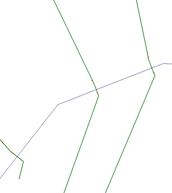
The station length and the XS cut line length end up equaling each other but sometimes aesthetically the main channel bank stations won’t have the river in between them as you see in the image below.
May 6, 2017 at 12:39 am #10567Jake GParticipantColin,
That sounds like a reasonable approach to editing the model, although you want to make sure the ends of the clipped cross sections still contain the peak flow. Also, in some cases it’s better to reduce the number of cross sections within a sharp bend.
Typically if you are removing points in the Cross Section Data editor and accepting the changes to the cut line, the bank stations should remain in place. They tend to get messed up if you’re using Remove Points from the Edit menu instead.
– Jake G.
June 5, 2017 at 6:22 pm #10568hrasuser12ParticipantThanks for the help Jake
-
AuthorPosts
- You must be logged in to reply to this topic.

