Welcome to the RAS Solution › Forums › HEC-RAS Help › 2D Unsteady analysis Exit Code = -1073741819
- This topic has 4 replies, 1,162 voices, and was last updated 8 years, 9 months ago by MW.
-
AuthorPosts
-
June 5, 2017 at 7:00 am #6493MWParticipant
Hi, I’ve got a 2D flow area with lateral connections to 1D river reaches. I’ve got 2 versions of the model, one with the 2D flow area being the existing terrain and one with a raised road embankment running straight through the middle of the 2D flow area.
The 1st case works (with the existing terrain) however i get this error message when i run the 2nd case to put in the updated terrain with the road embankment.
Error with program: RasUnsteady64.exe Exit Code = -1073741819
Everything else is the same except for the terrain. I’ve tried including the initial conditions ramp up time so the analysis doesn’t start dry and have tried swapping between Full Momentum and Diffusion wave equations. I’ve also got breaklines along the road embankment to define the raised topography.
Does anyone know what the error code refers to?
I think the issue has something to do with the different topography as that’s the only difference between both models. The road embankment can be up to 10m above the existing terrain which may be causing the stability issues but how do i get around that??Thanks for any help!
June 5, 2017 at 8:14 am #10626MWParticipantUPDATE:
I was able to run the model by reducing the time step to 20 seconds (it was 5 mintues before).
I had precipitation as the flow type for the 2D flow area in both cases 1 and 2 (existing terrain and terrain with road embankment running through).
The results with the road embankment seem to indicate almost no flooding/ water ponding happening anywhere within the 2D mesh. This seems strange as i’m using exactly the same unsteady flow file for both plans but the existing case runs with a great deal more ponding/ flooding than the 2nd case which is counterintuitive. I’d expect a lot more upstream ponding due to the road embankment.
Any guesses as to why these results are coming up?
Thank you!
June 5, 2017 at 4:30 pm #10627AnonymousGuestAs I understand, it sounds like there are no breaklines added into Case 2 with the terrain model that includes the road embankment feature. If that is the case, it seems possible the alignment of the 2D mesh cells is providing significant leaking through this embankment.
Perhaps adding breaklines along the road embankment to align cell faces with the top of the embankment would prevent this leaking, and provide the ponding you were expecting to see. Openings in this road embankment, and modeling them, ought to be considered, as well.
I hope this is helpful.June 6, 2017 at 1:57 am #10628MWParticipantHi markwood
Thanks for your response.
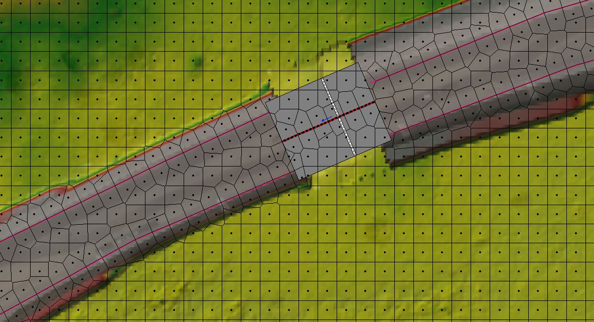
Below is a snapshot of how i had it modelled. I had breaklines to define the raised embankment. Where there are culvert crossings, I’ve created a gap in the terrain model and filled it in with a SA/2D Area Connection of weir/culverts.
If I read your explanation correctly, i’ve already addressed the issue of cell faces aligned with the top of embankment. Do you have any ideas about what else could be the problem?
Thanks so much for your help!
 January 11, 2019 at 8:56 pm #10629AnonymousGuest
I need some help regarding adding the precipitation in the HEC-RAS.
1- What does the actual mean of time series of precipitation? Is it mean the accumulated rainfall?
for exampleDate Simulation time Precipitation (mm)
11-01-2019 07:00 00:00 30
11-01-2019 08:00 01:00 30
11-01-2019 09:00 02:00 30Does it mean the total rainfall added on the 2D flow area during the whole simulation time is 90 mm? Please elaborate?
Thanks
-
AuthorPosts
- You must be logged in to reply to this topic.