Welcome to the RAS Solution › Forums › HEC-RAS Help › 1D-2D in HEC 5.0.7 – Lateral structure weir limited to 500 points?
- This topic has 4 replies, 664 voices, and was last updated 6 years, 10 months ago by SimR.
-
AuthorPosts
-
April 4, 2019 at 10:37 pm #7260SimRParticipant
I have a model with 1D Xsections coupled with 2D zones linked with lateral structures. It runs fine in HEC-RAS 5.0.6.
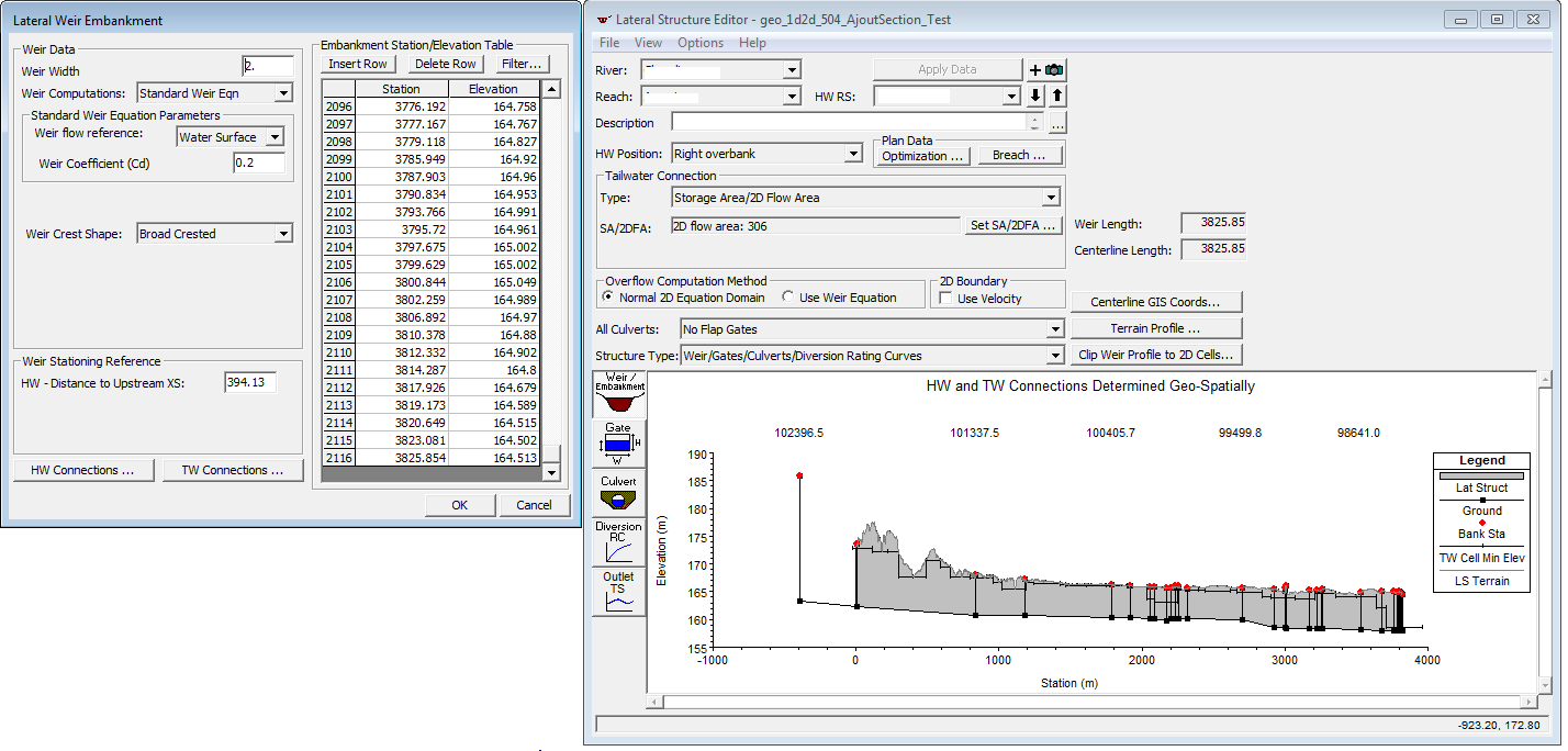
The model spans more than 50 kilometers and the lateral structures weir are following the terrain accordingly which results in around 3000 points in the lateral structure weir station/elevation.Trying to run this model in 5.0.7 results in errors for each of the lateral structures :
River: “Cha” Reach:”US” RS 1844.3 LS
-Weir data has more than 500 points the station elevation points. There is a limit of 500 pointsIt doesn’t seem to make sense to lose functionality with a new HEC-RAS version? Any 1D-2D model that spans a reasonable length is unusable with the new version? Am I the only one experiencing this issue?
April 5, 2019 at 1:30 am #12159Scott MillerParticipantThat is interesting the model ran with a 3000 point lateral structure. The 500 point station-elevation limit for lateral structures (and other alignments) is not new. It ought to have been necessary to break the lateral structure into several pieces to run in 5.0.6. It would be good to know what was going on. Was there an option to filter points that was applied before?
April 5, 2019 at 4:54 pm #12160SimRParticipantThanks for the answer Scott.
The model I have that runs has many lateral structures and spans more than 80 kilometers. This model was calibrated with observed data and is pretty stable for flows of 2 to 350 years.Every lateral structure has a couple thousand points in the Weir/Embankment Station/Elevation table. Those points were copy pasted from the Terrain Profile in the LS Editor.
Not sure I understand what was done differently for this model to allow well over 500 points for those LS without any error messages popping up. The lateral structures are broken in several pieces along one bank but all those pieces have a couple thousands points in the Embankment Station/Elevation table.
To give an example:
April 5, 2019 at 8:59 pm #12161Lonnie AParticipantI don’t at which version for sure but HEC removed the point # limit on lateral structures Ras but in V507 put it back in.
What I find in a lot of my model reviews is that folks put in too long of a lateral. It is hard to quantify flow diversions in long laterals when reviewing the hydrographs etc. They are also more prone to stability issues and if its broken up you it is easier to figure out the problem area.
My recomendation is to try and limit lateral lengths to no more than a mile. Typically I’ll add a seperate lateral across a tributary confluence. This gives you flexability in assigning weir coefficients specific to a location when needed (sometimes need to switch from weir equation to 2d equation and viceversa). I also recommend filtering the lateral points down. The lidar I use frequently has 3′ to 5′ pixel resolutions. I use the filter option and typically reduce the number of point to about 10% of what RAS brings in from the surface when I have laterals that are longer than say 500′. The more points and irregular the shape of the lateral the more instability potential you add.April 7, 2019 at 7:52 am #12162cameronParticipantI agree with Lonnie on splitting laterals down to about every mile or so and filtering them. It is a little bit of a pain sometimes, but it makes the models a lot more stable. Just remember that if you want to use the 2D equation instead of the weir coefficient, you have to split the lateral structures at cell faces.
-
AuthorPosts
- You must be logged in to reply to this topic.
