
February 20, 2025
Full Momentum Episode 37: All Things Gates
Gates play a crucial role in hydraulic modeling, impacting water flow, flood control, and dam operations.
Have you ever looked at your profile plot from an unsteady flow model and found “walls of water” on top of your bridge? Or just unexplained unrealistically large amounts of energy loss over a bridge? Take this for example:

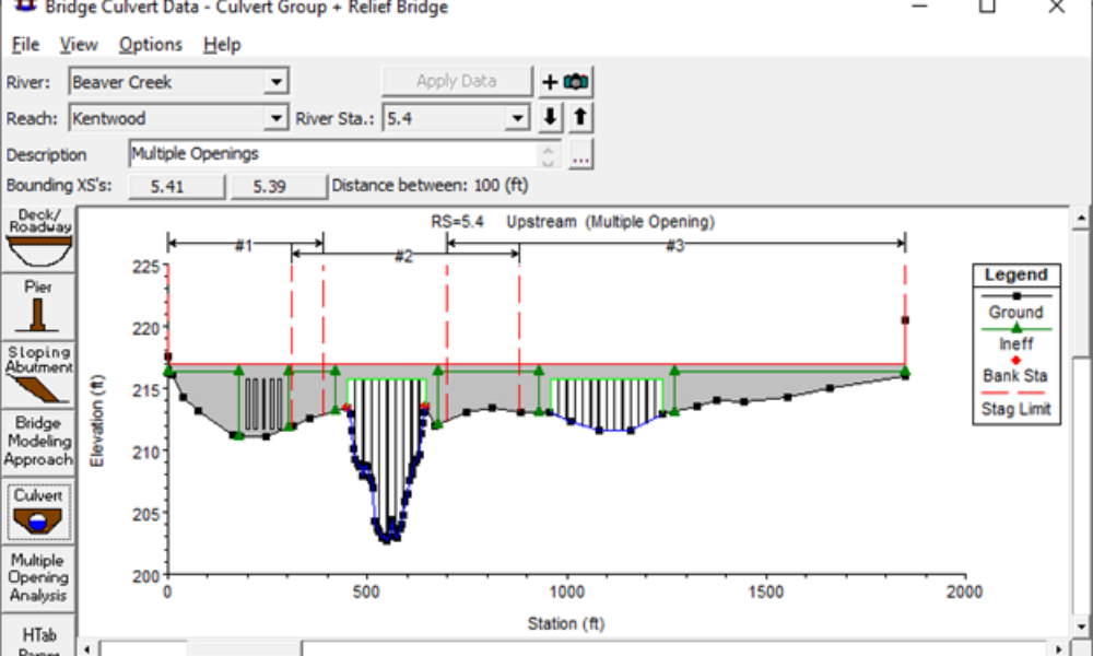
Notice the three large “steps” in energy grade line (and water surface elevation). It’s hard to see in the figure, but these all take place at bridges. The very first thing you should do in this case is review the HTAB parameters for the bridges.

Notice here the Head water maximum elevation is set to 773 m. If you look at the cross section of the plot behind it, the bridge deck itself is around 773 m in elevation. HEC-RAS uses the Head water maximum elevation to put an upper limit on the elevation that the HTAB rating curves are computed to.

If RAS is limited to rating curves that end abruptly at the bridge deck elevation, then any energy elevations computed during the simulation that are higher than the bridge deck were computed by extrapolation. By rule of thumb, any time HEC-RAS has to extrapolate, results can get strange, as we see in the first figure above. But, you don’t want to make your Head water maximum elevation too high, because that will stretch out the rating curves and decrease your resolution-also a bad thing in HEC-RAS unsteady flow.
The fix: Increase the Head water maximum elevation for the bridge to an elevation that is slightly greater than the maximum energy elevation that will occur at that bridge during the simulation. This of course requires an initial guess (we don’t know what the maximum elevation is until we run it), and generally some trial and error afterwards. In this case, I increased the Head water maximum for this bridge to 780 m. I also like to increase the Number of Points, Number of Submerged Curves, and Number of Points on each Submerged Curves to improve the resolution. I did the same thing for the other bridges in the data set. The result is an expanded range of HTAB rating curves for the bridge and a nice smooth water surface profile.


And you can check the cross section plot for the bridge to make sure your Head water maximum elevation is high enough (but not too high). Notice here the EG Max WS elevation is 773.99 m. We could probably lower the Head water maximum elevation to 775 m, but since it’s working fine at 780 m, I’ll leave it here.

Comments
The comments are closed.