
September 16, 2026
The No-Rise Surprise
Why Additional Conveyance Area Doesn’t Always Lower Water Surface
RAS Mapper is a window in HEC-RAS that allows you to preprocess 2D areas, map results, and manage background images. In future versions of HEC-RAS, RAS Mapper will become more and more prevalent in our HEC-RAS modeling experience. As I understand it, eventually RAS Mapper and the geometry editor window may merge to form the front-end interface for HEC-RAS, replacing the iconic “Main RAS Window”.

But that’s speculation. What is not speculation is that if you want to use HEC-RAS 5.0 for anything more than a very basic model, there is really no getting around using RAS Mapper, and by extension…The Projection File! The projection file defines a specific geographic coordinate system and projection and is somewhat of a new thing for us HEC-RAS modelers (it has actually been a part of RAS Mapper since it’s inception, but now with 2D modeling and web-imagery in Version 5.0, RAS Mapper is becoming an integral part of HEC-RAS modeling). The projection file requires us to know something about geospatial mapping (i.e. GIS), which we really haven’t had to know too much of before as RAS users. But if you wish to use RAS Mapper, and you will, you need to understand what the projection file is and how to get one. Without it, RAS Mapper is pretty much useless. Adding a projection file to our RAS project establishes the project’s geospatial reference. Projection files have the extension *.prj. Be careful not to confuse this with the HEC-RAS project file, also with an extension *.prj. They both reside in your HEC-RAS project directory, but only a properly formatted projection file will work in RAS Mapper for setting your projection.
The projection file is really just a simple text file with keywords in a specific format. In fact, it is a single string written in “Well-Known Text” format, or WKT. It’s simple, easy to read and was created by the Open GIS Consortium. Here’s what a projection file looks like on the inside. Notice that there are some keywords, identified by all CAPS, followed by some data related to the key-word, contained in brackets [ ]. I’ve color-coded it to make it easier to see what goes with what. The purple color denotes the highest order in the hierarchy, followed by blue, then green, then red. In other words, a red keyword is a “child” to a green keyword, green is a child to blue, and blue is a child to purple.

Each keyword and the bracketed data that follows is called a “clause”. The first and primary clause, PROJCS, stands for Projected Coordinate System. The projected coordinate system is made up of the following sub-clauses:
1. Geographic Coordinate System (GEOGCS), which is based on degrees latitude and longitude and contains the horizontal reference datum (DATUM), and the reference meridian for longitude measurements (PRIMEM). DATUM also contains a description of the shape of the earth (SPHEROID), which in the example above is the Clarke Ellipsoid of 1866. Units (UNIT) are inferred here only for the GEOGCS, in this case degrees.
2. Projection (PROJECTION), which is the projection from geographic coordinates (lat/long) to projected coordinates. This is essentially how the three-dimensional spheroid (Earth) is projected to a two-dimensional viewing medium. In the example above, Transverse Mercator is selected, which uses the Universal Transverse Mercator (UTM) coordinate system.
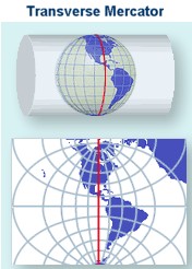
3. Various projection parameter values (PARAMETER). The parameter is labeled in quotations, followed by its value.
4. Units for the projected coordinate system (UNIT). Here meters are used as the linear unit with a conversion factor of “1”. The conversion factor converts the described units into meters. If “FOOT_US” is used, then the conversion factor would be 0.30480060960121924.
There may be some additional clauses in your projection file, but the ones listed above seem to be typical. All of the keywords used in WKT format with descriptions can be found at GeoAPI here.
You can write your own projection files and GeospatialPython.com presents a method (there are other examples out there, just Google it). However, it is much easier and much more practical to find an already-compiled projection file and use that. If you have a georeferenced HEC-RAS project already, every shapefile used to create your geometry components (stream centerline, xscutlines, flowlines, etc.) comes with a projection file. Just find where it is stored on your computer and use that.
If you don’t have the GIS files that were used to create your georeferenced HEC-RAS project, you can find projection files in at least three different places: ArcGIS 10.0 or earlier, spatialreference.org, and the EPSG Projection Database. If you know of others, please comment below!
When using any of these sources, make sure you pick the correct projection file. You’ll know if it is the right one by bringing in web imagery to RAS Mapper and checking to make sure that everything lines up spatially correct. ArcGIS (Versions prior to 10.1) includes a Coordinate Systems folder that contains more than 5,000 geographic, projected, and vertical coordinate systems. Unfortunately, newer versions of ArcGIS do not come with that folder. If you have ArcGIS 10.1 or newer or don’t have ArcGIS at all, you can access a large database of spatial reference systems at http://spatialreference.org/

If you go to spatialreference.org, make sure you only select from the EPSG, IAU2000, or spatialreference.org references. The ESRI references only contain the GEOGCS clause in the projection file and not the complete PROJCS clause. They will not work in RAS Mapper. Once you’ve found the reference you want, click on it, then select “.PRJ File” from the list of available formats. A projection file will then be downloaded to your computer and you are ready to use it in RAS Mapper. There is a convenient Search box that allows you to search on key words for your reference. For example, if your project is in Hawaii and you know your horizontal datum is NAD83, you can enter the keywords: Hawaii NAD83, click the Search button and you’ll see the following list of spatial references:

Also available on line is the EPSG Projection Database, hosted on GoogleCode by geospatialpython.org. Here you’ll find a text file of a multitude of projection files in the correct WKT format that can easily be copied and pasted into your own projection file.
Once you’ve selected a projection file and assigned it to RAS Mapper, double-check that it is correct by adding web imagery. If everything lines up, you are good to go. The figure below shows the Muncie dataset in RAS Mapper, with an incorrect projection file assigned.

Obviously our streamlines and cross sections in this example are not correctly aligned in Muncie Indiana where they belong. The incorrect projection file has landed us in the middle of Alberta, Canada!

Reassigning the correct projection file gets the model back to its correct spatial reference.


Does anyone know of any other sources of projection files that we can use in HEC-RAS? If so, please comment below.
Comments
The comments are closed.